This has been sitting as a draft for a while. Now that I’m in the corporate metropolis of Atlanta, GA for a market research conference, listening to sales people disguised as thought leaders talk about understanding what motivates people to eat fried chicken for breakfast and how to rig hidden cameras embedded in retail shelves to track and optimize people’s shopping behavior, I’m longing for a simpler place, so I finally got around to editing and publishing this.
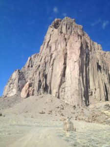
The town’s eponymous rock
This town is named after a rock that juts 482 meters out of the ground like a sail on a tall ship. The people we met there are just as straightforward as the name of the town. Shiprock is the largest Navajo community on the Navajo nation. We came here to visit Em’s friend, Jeanne, who is working as a doctor for the Indian Health Service.
One can see quite far out on the horizon around here, and the town’s eponymous rock always seems to be closer than it actually is. Utilizing an old envelope, Jeanne drew us a map that consisted of landmarks and roads she didn’t know the names of and, once we turned off the closest paved road, instructions to just go in the general direction of the rock. We first missed the turnoff and went between the two sides of a rock ridge just behind the Shiprock, so we improvised our loose plans and went to another area that had various other rock formations, including a rock with a hole in it, which may have been Window Rock, and one that looked like a mitten sticking straight out of the ground. Later, we learned it may have been the formation appropriately named Mitten Rock. Then again, it may not have been Mitten Rock because we weren’t exactly sure where we were.
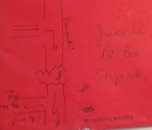
Directions hand written on an envelope

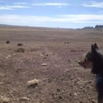
In the distance, a rock which may or may not be Mitten Rock
When we were about to return to the Shiprock, Em realized that we were about the same distance from Four Corners, where Em famously sneezed in four states at once last year. We decided to go there and see if I could conjure up a four state sneeze as well. This time, we relied on Google Maps because there were no useful signs and no people to ask. We crossed into Arizona and turned onto a small paved road which later turned into a flat dirt road which later turned into various winding paths where a donkey would have been more useful than a car. At this point, Em thought we should turn around, but I wanted to stay the course, thinking it would smooth out soon, seeing as how Google Maps was placing us right on the blue squiggly line that was the “best route” to Four Corners. Em made a point to let the record state that she wanted to turn around earlier. After we reached yet more challenging terrain, now complete with opportunities to roll off the side of a hill and no sign of things smoothing out, I conceded, and we turned back to the Shiprock, which provided the navigational advantage of sticking 482 meters into the sky.
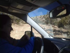
Since I only took this photo once I had settled down from worrying about whether the car was going to roll off the side of a hill, this doesn’t nearly do justice to how sketchy of a route we were on at other points.
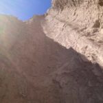
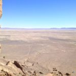
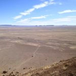
Aside from unnecessarily winding dirt trails across a flat plain that allow vehicular access to the rock and a paved road that services nearby towns, there is no sign of civilization within view from the rock. On rare occasion, a car will pass by on the paved road. On our way in on that winding trail, we saw a jogger followed by two vehicles leaving. While we were walking around, there was no one else within view, and looking up at the rock threw off our calibration of where gravity wanted to pull us. At these times, some miraculously alive squat green shrubs were the only proof that we hadn’t accidentally ended up on Mars.
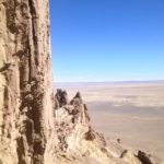
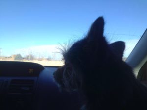
We had Jeanne’s tiny dog, Sir Didymus with us. Em, Diddy and I walked together part of the way up the dirt mound to the rock. The mound got steeper, and in characteristic fashion, Em turned back to wait in the car while I continued on with Diddy. About halfway up, Diddy started slowing down, and eventually, he stopped climbing on his own because he was uncertain about the terrain. I considered letting him run down to Em, but I wasn’t sure if he would run off somewhere else, and I also wasn’t sure if he would be able to manage the descent on his own, so I picked him up and carried him the rest of the way to the base of the rock. Jeanne told us that people are not allowed to climb the rock because it is sacred. Legend has it that a white man climbed it in the 1980s and the wind blew him off to his death. Once at the base, the views of the land below were quite impressive, and I realized I was much higher than I thought I was when I saw how small the car appeared. I carried Diddy most of the way down. He squirmed when he saw pebbles rolling down the hill. At some points, I had to walk backwards as if descending a ladder, but it worked out. Once Em was within earshot, she suggested I let Diddy run down to her on his own, which he did much quicker than I was able to stumble down. I thought he would not trust me to take him anywhere again after this adventure, but somehow, I think he actually saw it as a bonding experience. Once he got into the car, he looked to make sure I got back. And when Em started driving back to town, he laid down on my lap.
P.S. Jeanne’s colleague wrote this journal article, which beautifully illustrated the doctors’ relationships with the town and the patients in Shiprock.
P.P.S. Diddy has been missing for a couple of weeks. If you find him, please point him to Shiprock.